Discover the fascinating history and present-day significance of the Chickasaw map, a vital tool for understanding the Chickasaw Nation's ancestral lands and current jurisdictional area. From their original homelands in the southeastern United States to their modern presence in Oklahoma, these maps offer deep insights. We will explore how Chickasaw maps serve both historical preservation and contemporary navigation. Understanding the Chickasaw people's journey is crucial for appreciating their resilience and rich cultural heritage. These maps help us trace their movements and recognize their enduring sovereignty. Prepare to uncover the layers of history embedded within every Chickasaw map, providing an essential perspective for US audiences interested in Native American history and culture. This guide ensures you gain comprehensive knowledge, enhancing your understanding of this proud nation.
Where were the Chickasaw originally located?
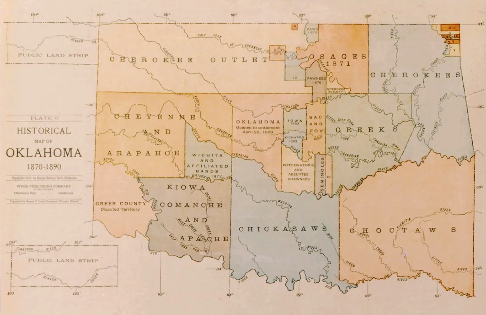
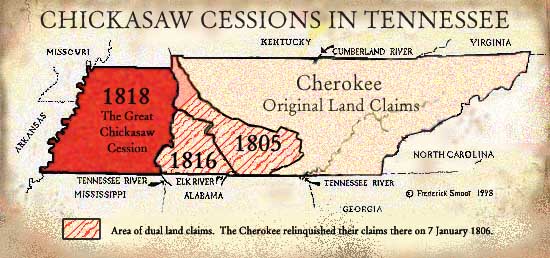
The Chickasaw people's original homelands were primarily located in what is now northeastern Mississippi, northwestern Alabama, and parts of Tennessee and Kentucky. These extensive territories were central to their cultural development and sovereignty before forced removal. Maps from the colonial era often depict their significant presence in these southeastern regions.
What states did the Chickasaw live in historically?
Historically, the Chickasaw lived across areas that eventually became Mississippi, Alabama, Tennessee, and Kentucky. Their traditional hunting grounds and settlements spanned these regions for centuries. These vast lands were integral to their identity and way of life. Understanding these historical states is key to tracing their past.
What is the Chickasaw Nation's current territory?
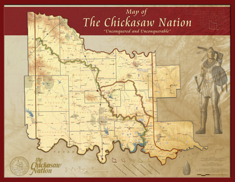
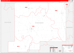
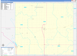
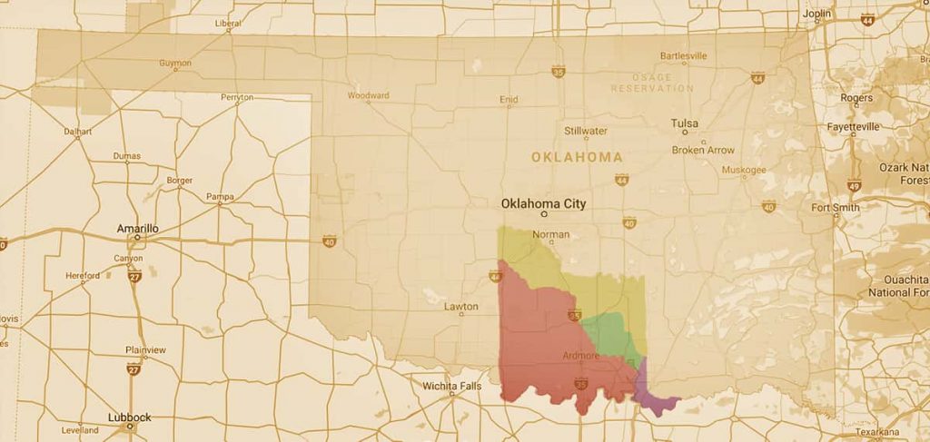
The Chickasaw Nation's current jurisdictional territory is located in south-central Oklahoma. It encompasses 13 counties, covering approximately 7,648 square miles. This area is where the Chickasaw Nation government provides services and exercises its sovereignty. The capital city is Ada, Oklahoma, serving as a hub for tribal operations.
What was the Chickasaw Trail of Tears route?
The Chickasaw Trail of Tears refers to the forced removal routes in the 1830s, moving the Chickasaw from their southeastern homelands to Indian Territory, present-day Oklahoma. Their journey primarily involved overland routes, some using existing roads like the Natchez Trace Parkway. These maps document the immense hardship and loss.
How do I find Chickasaw historical sites?
To find Chickasaw historical sites, consult official resources from the Chickasaw Nation, such as their cultural centers or website, which often provide detailed maps. Historical societies and state park services in Mississippi, Alabama, Tennessee, and Oklahoma also offer guides to significant locations related to Chickasaw history and presence. Online mapping tools can also pinpoint these important places.
When we talk about the Chickasaw map, we are diving into a rich tapestry of history, geography, and enduring sovereignty. This map primarily illustrates the ancestral lands of the Chickasaw people, detailing their presence across significant portions of what is now the southeastern United States. It also highlights their journey during the Indian Removal era and their vibrant, self-governing nation located in south-central Oklahoma today. Understanding this map is crucial for anyone interested in Native American history and the ongoing legacy of the Chickasaw Nation.
The Chickasaw people historically thrived in regions encompassing parts of Mississippi, Alabama, Tennessee, and Kentucky. Their story is one of resilience, cultural preservation, and continuous adaptation. By studying the Chickasaw map, we gain insight into their strategic locations and their deep connection to the land. This visual representation serves as a powerful educational tool for all.
Navigating the Chickasaw Map Through Time
Exploring a Chickasaw map offers a unique journey through different historical periods. You can trace their pre-removal territories, showing where they lived for centuries before forced relocation. These maps reveal a powerful narrative of strength and independence. Understanding these geographical shifts is key to appreciating their history.
What is the historical extent of the Chickasaw map?
The historical Chickasaw map traditionally spans large areas of present-day Mississippi, Alabama, Tennessee, and Kentucky. These lands were their ancestral homelands, rich in resources and cultural significance. The Chickasaw Nation maintained control over these territories for centuries. Their deep connection to this land is a fundamental aspect of their identity.
Where is the Chickasaw Nation located today on a map?
Today, the Chickasaw Nation's jurisdictional territory is primarily in south-central Oklahoma. This area encompasses 13 counties and is where the tribal government operates. It is a vibrant community with diverse cultural sites. Modern maps clearly delineate these sovereign boundaries for clarity.
What does the Chickasaw map tell us about the Trail of Tears?
The Chickasaw map dramatically illustrates the forced removal routes, known as the Trail of Tears. It shows the arduous journey from their homelands to Indian Territory, which is now Oklahoma. These maps serve as a poignant reminder of immense hardship endured. They document a critical period in Chickasaw history.
Why is understanding the Chickasaw map important for US citizens?
Understanding the Chickasaw map is vital for US citizens to grasp Native American history and sovereignty. It educates about land treaties, cultural heritage, and the ongoing contributions of indigenous peoples. This knowledge fosters a more complete understanding of America's past and present. It promotes respect for tribal nations.
Key Geographic Details of the Chickasaw Map
Here is a concise overview of significant locations related to the Chickasaw map:
| Region | Significance for Chickasaw Map | Current Status |
|---|---|---|
| Southeastern USA | Ancestral Homelands | Historic Territory |
| Mississippi | Core Original Territory | Former Chickasaw Land |
| Oklahoma | Current Jurisdictional Area | Sovereign Nation Base |
| Tishomingo | Historic Capital (Oklahoma) | Cultural and Historic Site |
| Ada | Current Capital (Oklahoma) | Administrative Center |
What Others Are Asking?
What states did the Chickasaw live in historically?
Historically, the Chickasaw people inhabited vast areas across what are now the states of Mississippi, Alabama, Tennessee, and Kentucky. These lands formed their traditional homelands for centuries. Their territory was well-defined before forced removal. This rich history is often depicted on early maps.
What is the Chickasaw Nation's current territory on a map?
The Chickasaw Nation's current territory, as shown on a map, is located in south-central Oklahoma. It covers a 7,648-square-mile area across 13 counties. This is their recognized jurisdictional area. The capital city of the Chickasaw Nation is Ada, Oklahoma.
How can I find Chickasaw historical sites using a map?
You can find Chickasaw historical sites by consulting specialized maps from the Chickasaw Nation's official website or cultural centers. These maps often highlight important places like battlegrounds, ancient villages, and significant removal routes. Online resources and physical visitor centers also provide detailed navigational assistance.
Is the Chickasaw Nation a sovereign nation on the map?
Yes, the Chickasaw Nation is indeed a federally recognized sovereign nation, and its boundaries are clearly marked on modern jurisdictional maps. This sovereignty means they govern their own citizens and territory within the United States. Their maps reflect this important political status.
What kind of Chickasaw map resources are available for education?
Numerous educational Chickasaw map resources are available from tribal organizations, historical societies, and universities. These include interactive digital maps, historical atlases, and detailed lesson plans for all age groups. They often focus on history, culture, and geographic impacts. These tools are excellent for learning.
FAQ about the Chickasaw Map
What is the Chickasaw map?
The Chickasaw map visually represents the historical territories and current jurisdictional lands of the Chickasaw Nation. It is a critical tool for understanding their history, cultural footprint, and sovereign presence in the United States.
Who created the first Chickasaw maps?
Early maps depicting Chickasaw territories were often created by European cartographers based on indigenous knowledge and exploration. Today, the Chickasaw Nation itself creates and curates detailed maps reflecting their history and modern governance.
Why is the Chickasaw map significant?
The Chickasaw map is significant because it tells the story of an enduring people, their ancestral domain, their forced removal, and their continued self-governance. It serves as a testament to their resilience and cultural strength.
How does the Chickasaw map help visitors?
The Chickasaw map helps visitors navigate cultural sites, historical markers, and tribal facilities within the Chickasaw Nation's current territory in Oklahoma. It guides people to museums, parks, and other important destinations for a richer experience.
Historical territories, current jurisdictional boundaries, Trail of Tears routes, cultural sites, tribal sovereignty, educational resources, navigation of Chickasaw Nation properties
35


Chickasaw Maps Geography And Power Chickasaw Tv CNTV HC Map3 Thumb 416x . Map Of Chickasaw Map Indicating Location Of Current Chickasaw Nation And Location Of Original Chickasaw . Chickasaw Nation Map Cartography Publishing Services GISCAPS Chickasaw Nation Map Back . TN History For Kids Chickasaw Nation 1 Chick . Map Of Chickasaw Nation Boundary And Legislative District


Chickasaw Nation Map Cartography Publishing Services GISCAPS Chickasaw Nation Map Back 500x383@2x . Chickasaw Nation Map Cartography Publishing Services GISCAPS Chickasaw Nation Map Pdf 1 . Chickasaw County MS Map Book Premium Chickasaw Ms . Chickasaw Nation Google Search Chickasaw Nation Chickasaw . NPS Atlas Chickasaw National Recreation Area Oklahoma U Gri Map Chic


Natchez Trace Parkway Highlights 4 Day Road Trip Itinerary The Chickasaw Homelands Map . Chickasaw Nation Chickasaw Nation . Climate And Water Monitoring At Chickasaw National Recreation Area Fig1 CHIC Map 800 . Chickasaw County Mississippi 2025 Aerial Wall Map Mapping Solutions Chickasaw MS Aerial Wallmap 36x36 . The Chickasaw Cession Hill Country History Native American Tribes


Previsi N Del Tiempo Para Chickasaw . Chickasaw Electric Cooperative Power Outages Live Outage Map Chickasaw Electric Cooperative . The Presidents House Chickasaws Visit President Washington . Chickasaw Citizen Groups Chickasaw Nation .aspx. Chickasaw County MS Wall Maps MapSales Chickasaw Ms
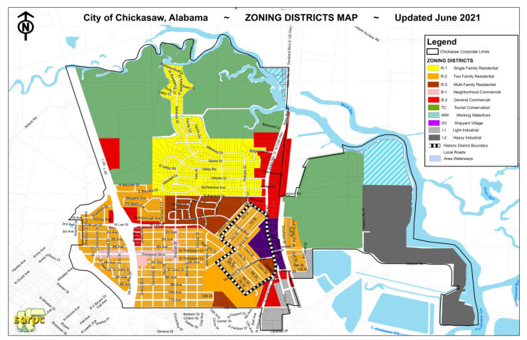
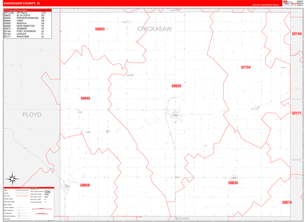

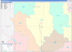
Chickasaw County MS Map Book Basic Chickasaw Ms . Businesses City Of Chickasaw Alabama Chickasaw Zoning Small 6 2021 Sm . Chickasaw County IA Zip Code Wall Map Red Line Style By MarketMAPS Chickasaw Ia . Cession Brm2026 Lusher Mississippi Chickasaw 1835 3000x2300 . Chickasaw County IA Wall Maps MapSales Chickasaw Ia
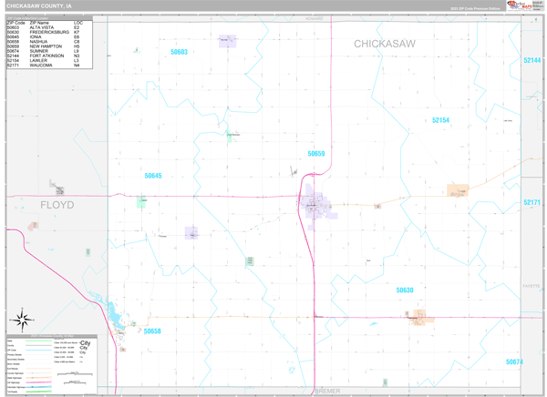
Maps Of Chickasaw County Iowa Marketmaps Com Chickasaw Ia . Chickasaw County MS Wall Maps MapSales Chickasaw Ms . Chickasaw Nation Oklahoma Native News Historical Map Of Oklahoma 1870 1890 Indian. Chickasaw County IA Wall Maps MapSales Chickasaw Ia . The Chickasaw And Their Cessions Chickmap


Chickasaw National Recreation Area Map By US National Park Service CHICmap1 Preview 2 . The Chickasaws And Their Nation Fa1207 . Description Of Battle Of Chickasaw Bayou . Chickasaw Nation Chickasaw Nation Map In Oklahoma 1024x487 . Chickasaw County IAGenWeb Map Index Cities Po