Unveiling the captivating map of US islands is an exciting journey for any explorer. From the sun-drenched beaches of the Caribbean territories to the rugged Alaskan archipelagos, the United States boasts an incredible array of island destinations. This comprehensive guide helps you navigate these diverse landscapes. Discover essential details about various US island groups, their unique cultures, and breathtaking natural beauty. Whether planning a serene getaway or seeking adventure, a detailed map of US islands provides crucial navigational insights. Learn about popular vacation spots, historical significance, and ecological wonders that make these islands so special. Explore how understanding the geographical spread of US islands enhances your travel planning and appreciation for America's expansive territories. This information is key for anyone looking to explore the hidden gems and well-loved paradises across the nation's island network. Our focus is to provide clear, actionable information about these incredible American treasures.
What are the primary categories of US islands shown on a map of US islands?
On a map of US islands, you'll find several primary categories: the Hawaiian Islands, US territories in the Caribbean (Puerto Rico, US Virgin Islands), US territories in the Pacific (Guam, American Samoa, Northern Mariana Islands), and numerous coastal and lake islands within the continental US, such as the Florida Keys or islands off New England.
Do I need a passport to visit all US islands?
No, you do not need a passport to visit all US islands if you are a US citizen. Travel to US states like Hawaii or territories such as Puerto Rico and the US Virgin Islands does not require a passport. However, if your itinerary involves connecting through foreign countries, a passport may be necessary.
Which US islands are known for their historical significance?
Many US islands boast rich historical significance. For instance, Ellis Island in New York is famous as an immigration gateway. Puerto Rico's Old San Juan features historic forts and colonial architecture. Hawaii's Pearl Harbor is a poignant reminder of WWII history. These islands offer compelling historical narratives for visitors.
Are there US islands suitable for eco-tourism?
Absolutely, many US islands are ideal for eco-tourism. American Samoa offers pristine rainforests and coral reefs in its National Park. Hawaii provides unique volcanic ecosystems and diverse marine life. The US Virgin Islands protect significant marine habitats. These destinations emphasize sustainable tourism and natural preservation efforts.
What resources are available to get a detailed map of US islands for travel?
Detailed maps of US islands for travel are widely available. Online mapping services like Google Maps or Bing Maps provide interactive views. Specialized travel guides and atlases often include comprehensive island maps. Official tourism websites for individual islands also offer detailed local maps, perfect for planning your adventure effectively.
When we talk about the map of US islands, we're discussing a truly vast and varied collection of landmasses. These islands range from popular tourist havens to remote, protected ecosystems. They are found across the Atlantic and Pacific oceans, and even within the Great Lakes. Understanding this geographical spread helps us appreciate America's diverse territories and natural wonders. Travelers and researchers alike find immense value in exploring these unique island locations. Our purpose today is to help you confidently navigate the incredible world of US islands.
Understanding the map of US islands is vital for travel and education. It reveals a tapestry of American influence and natural splendor. These islands offer everything from vibrant cities to tranquil beaches. Each island carries its own story and distinct identity, making them fascinating to explore. Let's dive into some of the most remarkable island groups the United States proudly encompasses.
Exploring the Diverse US Islands Landscape: What Awaits?
The map of US islands showcases incredible geographical diversity. You will find volcanic peaks, coral reefs, and sandy coastlines. This variety supports unique ecosystems and offers countless adventures for visitors. Exploring these diverse landscapes is an unforgettable experience. From the subtropical warmth to the temperate climates, US islands cater to every preference.
The Tropical Allure: Caribbean US Islands on Your Map
The US Virgin Islands and Puerto Rico stand out on any map of US islands for their Caribbean charm. These territories offer stunning beaches, rich history, and vibrant cultures. They are popular destinations for American tourists seeking sun and relaxation. Visitors enjoy activities like snorkeling, sailing, and exploring historic towns. These islands are easily accessible and provide a taste of paradise.
Pacific Wonders: Uncovering the Map of US Islands in the Ocean
Venturing to the Pacific side of the map of US islands reveals territories like Guam and American Samoa. These islands present a blend of indigenous traditions and breathtaking natural beauty. They are perfect for those seeking remote adventures and unique cultural immersion. Their pristine waters and lush landscapes offer unparalleled experiences. Discover ancient sites and diverse marine life in these distant treasures.
Mainland Gems: Coastal and Lake Islands on the Map of US Islands
Even within the contiguous United States, the map of US islands holds many treasures. Think of the scenic Outer Banks of North Carolina or the charming islands off New England. These destinations provide a different kind of island experience, often rich in history and maritime culture. Islands in the Great Lakes also offer serene escapes. They are perfect for shorter trips and outdoor activities closer to home.
Planning Your Island Escape with a Map of US Islands: Essential Tips
Planning your next getaway requires a good understanding of the map of US islands. Consider what type of experience you desire: relaxation, adventure, or cultural immersion. Researching climate, local customs, and travel requirements is always smart. Many US islands offer direct flights, making them convenient destinations. Preparing well ensures a smooth and enjoyable island adventure.
A detailed map of US islands can truly enhance your travel planning. It helps visualize distances, identify key attractions, and understand regional nuances. Whether you prefer a digital map or a traditional paper one, having this tool is invaluable. Use it to discover hidden coves, local eateries, and perfect photo opportunities. Let your map be your guide to unforgettable American island explorations.
Navigating the Beauty of US Islands Table
Here is a quick overview of some prominent US island regions and their key features.
| Island Region | Key Features | Popular Activities | Climate |
| Puerto Rico | Rich history, diverse landscapes, vibrant culture | Old San Juan exploration, El Yunque rainforest hikes, beach relaxation | Tropical |
| US Virgin Islands | Stunning beaches, snorkeling, sailing | Beach hopping, water sports, historical sites | Tropical |
| Hawaii | Volcanic landscapes, surfing, unique culture | Volcano National Park, surfing, luaus | Tropical |
| Guam | Pristine beaches, Chamorro culture, diving | Scuba diving, cultural tours, WWII historical sites | Tropical |
| American Samoa | Rugged beauty, unspoiled nature, Samoan culture | National Park of American Samoa, hiking, snorkeling | Tropical |
| Florida Keys | Coral reefs, fishing, relaxed atmosphere | Key West attractions, fishing charters, diving | Subtropical |
| Outer Banks, NC | Historic lighthouses, wild horses, surfing | Beach activities, exploring historic sites, nature photography | Temperate |
| Martha's Vineyard, MA | Charming towns, beautiful beaches, cycling | Lighthouse tours, art galleries, seafood dining | Temperate |
What Others Are Asking?
What are the major US territories and where are they located on a map of US islands?
The major US territories include Puerto Rico and the US Virgin Islands in the Caribbean, and Guam, American Samoa, and the Northern Mariana Islands in the Pacific. On a map of US islands, Puerto Rico and the US Virgin Islands are east of Florida, while the Pacific territories are scattered across the vast Pacific Ocean, west of the continental US.
Are the Hawaiian Islands considered US islands or a separate entity?
The Hawaiian Islands are absolutely considered US islands. Hawaii is the 50th state of the United States. Its unique volcanic geography and Polynesian culture are integral to the nation's diverse island landscape. A map of US islands always prominently features this Pacific paradise, highlighting its significance within the country.
What is the easiest US island to travel to for a vacation?
For most US travelers, Puerto Rico or the US Virgin Islands are often the easiest to access. They do not require a passport for US citizens, offering direct flights from many mainland cities. The Florida Keys also provide excellent accessibility by car, making them a very convenient and popular US island destination for many. Both offer diverse attractions.
Which US islands have the most unique wildlife and natural beauty?
Hawaii and American Samoa stand out for their exceptional biodiversity and natural beauty on the map of US islands. Hawaii's volcanic landscapes, lush rainforests, and endemic species are incredible. American Samoa offers pristine coral reefs, untouched rainforests, and unique marine life, providing unparalleled natural experiences for visitors. Both are ecological treasures.
Can I find a comprehensive map of US islands including both states and territories?
Yes, many geographical resources and online mapping tools offer comprehensive maps of US islands. These maps typically include all 50 states, detailing coastal and lake islands, alongside the various US territories. Such detailed maps are invaluable for understanding the full extent of America's island geography, perfect for trip planning or education.
FAQ
Who manages the various US islands?
Different US islands are managed by various entities. States oversee their coastal and lake islands, while the federal government, often through the Department of the Interior, governs the unincorporated territories like Puerto Rico and Guam. This complex structure ensures unique regional governance.
What types of experiences do US islands offer?
US islands offer a spectrum of experiences, from relaxing on pristine beaches and engaging in water sports to exploring historical sites and hiking through lush rainforests. You can find vibrant nightlife, serene natural escapes, and rich cultural immersion. Each island provides a unique adventure.
Why are some US islands considered territories and not states?
US islands like Puerto Rico and Guam are territories because they have not been formally admitted into the Union as states. This status grants their residents US citizenship but often limits federal voting rights and representation in Congress. Their future political status remains a topic of discussion.
How can I best plan a trip using a map of US islands?
To plan a trip using a map of US islands effectively, first identify your desired climate and activities. Then, research accessibility, passport requirements (if applicable), and local attractions. Online interactive maps and travel guides provide current information to help you select and plan your perfect island getaway.
Key Takeaways About the Map of US Islands
The map of US islands reveals an extraordinary range of destinations. From the vibrant Caribbean to the tranquil Pacific, these islands offer diverse experiences. Understanding their geography and unique characteristics enhances travel planning. Whether seeking adventure or relaxation, the US island network has something for everyone. Explore, discover, and enjoy these incredible American treasures with confidence.
Diverse geography of US islands, unique cultural experiences on US islands, breathtaking natural beauty, essential travel planning using a map of US islands, popular destinations across US territories, ecological significance of US island regions.

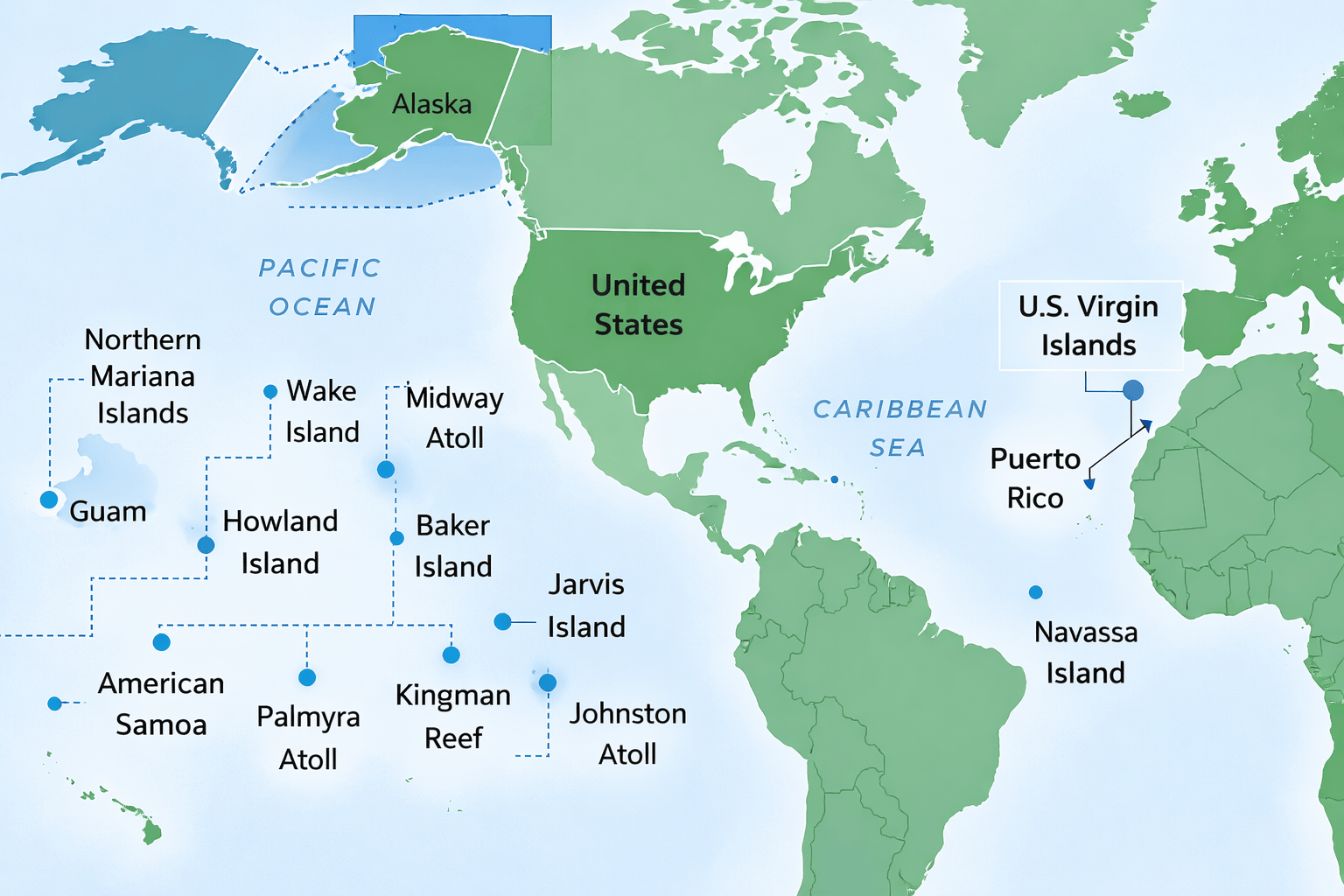


Map Of Us And Islands Printable Map Of The US Map Of U S Territories 2 . Geography CornerU S Territories Explained Caribbean And Pacific Regions US Virgin Islands . QAWAN Quran Muka 599 Www QawanQuran Com Us Territories Map . Map Of USA And Surrounding Islands United States Virgin Islands History Geography Maps Britannica Inside Map Of Usa And Surrounding Islands 1024x840 . Another Map Of The US For All You Map Lovers Page 30 The Coffee


2020 Population Of U S Island Areas Just Under 339 000 First 2020 Census United States Island Areas Data Released Today Map 1 . U S Continues To Close Mapping Gaps On Ocean Coastal And Great Lakes Unmapped January 2026 Layout With ECS And Arctic Boundary 1024x572 . Islands Of West Coast Of America NGK US Virgin Islands Map Square . Science Exploration NOAA Ocean Exploration 2026 Field Season Map . Map Of Islands Off Coast Of United States California An Island Meet Eez Unmapped Noaa United States 2021


40th Annual 1000 Islands Kingston Poker Run 2026 Poker Runs America 1000 Islands 2026 Map REVISED . Us Virgin Islands Of The United States Political Map Detailed U S Virgin Islands Of The United States Political Map Detailed With Isolated . Islands Of The United States Including The Map Largest Islands Contiguous Usa . 2020 Population Of U S Island Areas Just Under 339 000 First 2020 Census United States Island Areas Data Released Today Map 2 . Exploring America 45 Maps That Might Shift Your View Of The US Bored Jpeg 700


User Times Online Com Potts Potts Launches Updated 2026 Press Release 0531521 229093 . Experience The 2026 World Cup In An RV Road Trip Guide Map Of 2026 World Cup Locations 1024x812 . The Ultimate Risk Map Of 2026 SAFETURE Riskmap 2026 OCEANIA 260507 Scaled . 2026 Census Test 2026CT National Sites Map Large . World Map And Year 2026 Of The World Map With The Year 1000 F 1754974276



How Many Islands Are There In United States In 2026 Island In United States . Map Of United States Outside Of The Islands Map United States America Usa Territories Islands Different Variations Your Design Stock Vector Name Blue 179397718 . Map Of Us And Surrounding Islands Printable Map Of The US Leeward Islands Wikipedia Printable Map Of Us Virgin Islands . Map Of The USA And Caribbean Islands United States Virgin Islands History Geography Maps Britannica Inside Map Of The Usa And Caribbean Islands . It S Time For Mapping USA 2026 US 2025 09 Musa Header



File 2026 United States House Of Elections Retirements 3840px 2026 United States House Of Elections Retirements Or Losses Of Map.svg . Extended Cruise Vacations Best Long Cruises Across The U S Classic Great Us 2026 Map 1430x800 . Exploring The Map Of Lower USA What Does It Include 1000 F 1754973895 . ORION ISLAND WAVES 2026 Lineup Timetable Map 2026 Map . 13 Day Four Islander 2026 Perillo Tours Map11327


The Ultimate Risk Map Of 2026 SAFETURE Riskmap 2026 260507 Scaled . Colorful World Map Showing Continents Island And Ocean With Text Happy Colorful World Map Showing Continents Island Ocean Text Happy New Year Generated Ai 427284599 . Last Frost Date Predicted For 2026 Last Frost Date Map The Almanac 2026 US Spring Weather Forecast 2 . U S Navy The Heritage Foundation 2026 MAP 14 . M5 6 Earthquake Southeast Of Easter Island August 8 2026 Intensity