Understanding the tundra environment is crucial for appreciating Earth's diverse ecosystems. A map of the tundra offers vital navigational and informational insights into these unique polar and alpine regions. These maps highlight permafrost distribution, distinct vegetation zones, and crucial wildlife migration routes across the United States and globally. Trending in 2026, detailed tundra maps help researchers track climate change impacts, aiding conservation efforts and resource management. They also serve as essential tools for adventurers and educators alike, providing rich data on topography and ecological features. Exploring a tundra map opens a window into a world of extreme conditions and surprising biodiversity, a truly captivating geographical study.
What is the definition of tundra on a map?
On a map, tundra designates vast, treeless biome characterized by permafrost, a layer of permanently frozen subsoil. It typically appears in extreme northern latitudes or high altitudes. This unique environment supports low-growing vegetation like mosses, lichens, and dwarf shrubs, distinguishing it from forested regions. Tundra maps help visualize these cold, harsh, yet ecologically vital landscapes globally.
Which U.S. states contain tundra regions?
In the United States, Alaska is the primary state with extensive tundra regions. Both Arctic tundra, found in the northern parts of the state, and alpine tundra, prevalent in its mountainous areas like the Alaska Range, are significant. Small pockets of alpine tundra can also be found in high elevations of states like Colorado and Wyoming in the Rocky Mountains.
How does climate change impact the areas shown on a map tundra?
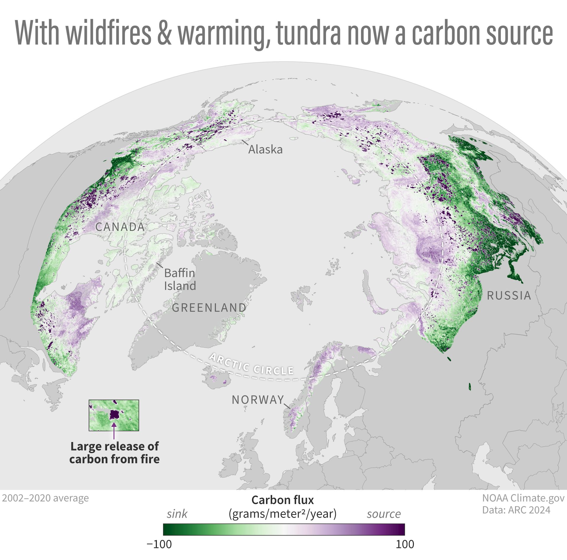
Climate change significantly impacts areas shown on a map tundra by causing permafrost to thaw, leading to altered landscapes, increased erosion, and changes in hydrology. These maps often update to reflect shifting treelines, new vegetation growth, and the expansion of wetlands. The changes observed on these maps highlight habitat loss for many arctic species and the release of greenhouse gases from thawing ground.
What are the different types of tundra illustrated on maps?
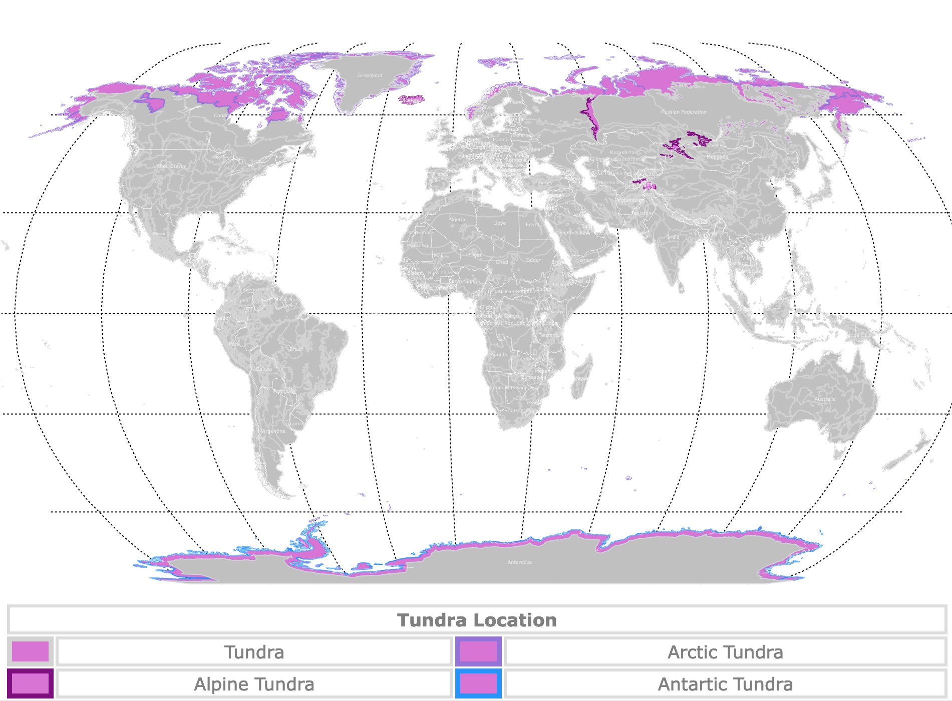
Maps typically illustrate two main types of tundra: Arctic tundra and alpine tundra. Arctic tundra is found in polar regions at low altitudes, characterized by continuous permafrost. Alpine tundra occurs on high mountains worldwide above the tree line, often without permafrost. Some maps might further differentiate based on moisture levels, showing moist tundra or dry tundra within these broader categories.
Why is a map tundra crucial for understanding biodiversity?
A map tundra is crucial for understanding biodiversity because it visualizes the geographical distribution of distinct cold-adapted ecosystems. These maps pinpoint critical habitats for unique species like caribou, arctic foxes, and specialized plants. By showing where specific tundra types exist, maps help researchers assess biodiversity hotspots, track species movements, and identify areas needing conservation efforts, which is vital for protecting vulnerable wildlife.
Can a map tundra show human settlements or infrastructure?
Yes, a map tundra can certainly show human settlements and infrastructure, though these are often sparse due to the harsh conditions. Larger-scale or regional tundra maps might display remote villages, research stations, pipelines, roads, or even traditional hunting and fishing areas. These features provide context for human interaction with these extreme environments, highlighting resource extraction or conservation zones.
What future changes might we see on a map tundra by 2050?
By 2050, a map tundra might show significant changes including further permafrost degradation, leading to altered coastlines and increased thermokarst lakes. Treelines are projected to advance northward and to higher elevations, encroaching on current tundra areas. Vegetation patterns will likely shift, with more shrubs replacing mosses and lichens. These maps will reflect a landscape actively transforming due to accelerated global warming impacts.
Have you ever wondered about the vast, treeless landscapes that define some of Earth's coldest regions? A map of the tundra unveils these incredible environments, showing us where these unique ecosystems exist and what makes them so special. From the Alaskan wilderness to high mountain peaks, tundra maps are essential for understanding these often-harsh yet beautiful territories. They provide crucial details for navigation, research, and simply appreciating our planet's diverse geography. As we move into 2026, these maps are more important than ever for tracking environmental changes.
The tundra, characterized by its perpetually frozen subsoil known as permafrost, covers significant portions of the northern hemisphere. This includes parts of Alaska in the United States, as well as Canada, Russia, and Scandinavia. Understanding a map tundra helps us grasp the distribution of these fragile biomes, which are profoundly affected by global warming. These maps often illustrate the boundaries between arctic tundra and alpine tundra, revealing distinct ecological zones. They are invaluable for scientists studying climate patterns and the impacts on local wildlife populations.
For those interested in exploring or simply learning about these remote areas, detailed maps offer a wealth of information. They can highlight specific topographical features, identify protected areas, and even show traditional hunting grounds. The accuracy of a map tundra allows for safer travel and more informed conservation strategies. It is truly fascinating to see how life adapts and thrives in such challenging conditions, often visible through the patterns and features depicted on these specialized maps. Exploring these maps feels like taking an expedition from the comfort of your home.
Understanding the Tundra Through Mapping
Mapping the tundra involves more than just outlining its geographical extent. It includes detailing vital aspects like soil composition, vegetation types, and hydrological features. A good map tundra provides a layered view, showing how permafrost depths vary and where unique plant species like mosses and lichens dominate. This level of detail is critical for researchers assessing ecological health and biodiversity. It helps us see the intricate connections within these cold, yet vibrant, landscapes.
The Role of Permafrost in Tundra Maps
Permafrost is a defining characteristic of the tundra, and its presence is clearly depicted on specialized map tundra versions. This permanently frozen ground shapes the landscape, influencing drainage patterns and limiting tree growth. Changes in permafrost distribution, often shown through historical and current mapping data, are key indicators of climate change. These maps are vital tools for predicting future environmental shifts across the Arctic and alpine zones. Observing these changes helps us understand global warming better.
Tundra Ecosystems and Their Representation on Maps
Tundra ecosystems are surprisingly diverse, supporting a range of cold-adapted flora and fauna. A map tundra can effectively illustrate the various sub-regions within the tundra, such as moist tundra, dry tundra, and polar deserts. These distinctions are crucial for understanding habitat distribution for animals like caribou, arctic foxes, and polar bears. By mapping these specific ecological zones, we gain a clearer picture of conservation priorities and biodiversity hotspots. Each map tells a unique story of survival.
What Others Are Asking? The Map Tundra
What defines the tundra on a map?
A tundra on a map is typically defined by its cold, treeless landscape and the presence of permafrost, which is permanently frozen subsoil. These maps often highlight vast, open areas in high latitudes or altitudes where low-growing vegetation like mosses, lichens, and dwarf shrubs thrive. They show regions where the annual average temperature remains below freezing, preventing the growth of tall trees and shaping distinct geographical features.
Where are the major tundra regions located globally?
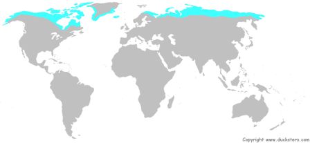
Globally, major tundra regions are primarily found in the Arctic, encircling the North Pole, and as alpine tundra on high mountain ranges worldwide. The vast Arctic tundra spans northern Canada, Alaska in the United States, Siberia in Russia, and coastal areas of Greenland and Scandinavia. Alpine tundra appears in mountain ranges like the Rockies, Andes, and Himalayas, regardless of their latitude, above the tree line.
How does permafrost appear on a map tundra?
On a specialized map tundra, permafrost is often indicated through color-coding, shading, or specific symbols that denote areas of continuous, discontinuous, or sporadic permafrost. These visual cues help distinguish regions based on the extent and depth of their frozen ground. Maps might also show historical permafrost extents versus current distributions, highlighting areas undergoing thaw due to climate change, offering critical insights into environmental shifts.
What types of vegetation are shown on a map tundra?
Vegetation on a map tundra typically showcases low-growing plant life adapted to cold, harsh conditions. These maps might use different patterns or colors to represent mosses, lichens, sedges, grasses, and dwarf shrubs like willows and birches. Tall trees are conspicuously absent. The density and type of vegetation often indicate variations in soil moisture and permafrost presence, offering a detailed botanical overview of the region.
Why is mapping the tundra important for climate change studies?
Mapping the tundra is critically important for climate change studies because it helps scientists track the rapid changes occurring in these sensitive environments. Tundra maps reveal permafrost thaw, which releases potent greenhouse gases, and shifting vegetation patterns, impacting global carbon cycles. These maps allow researchers to monitor glacial retreat, sea ice reduction, and habitat loss for arctic wildlife, providing crucial data for understanding and predicting global climate impacts.
FAQ About the Map Tundra
Who uses a map tundra?
Scientists, environmental researchers, adventurers, climate modelers, and indigenous communities all use tundra maps. These maps aid in studying ecosystems, planning expeditions, monitoring environmental changes, and managing traditional lands effectively. They are essential for understanding these unique regions.
What is a map tundra used for?
A map tundra is used for geographical study, environmental monitoring, navigation in remote areas, and conservation planning. It helps visualize permafrost distribution, track wildlife movements, assess climate change impacts, and understand unique polar and alpine ecosystems. The uses are quite diverse.
Why is the map tundra changing?
The map tundra is changing primarily due to global climate change. Rising temperatures are causing permafrost to thaw, altering landscapes, hydrology, and vegetation patterns. These shifts are visible on updated maps, reflecting significant environmental transformations in these sensitive regions. It's a critical area of study.
How do maps show different types of tundra?
Maps show different types of tundra through various labeling, color-coding, and symbolic representations. They distinguish between Arctic tundra, alpine tundra, and even sub-types like moist or dry tundra. These visual cues help users understand the specific ecological characteristics and geographical distributions of each tundra variation, providing clear insights.
| Tundra Type | Key Characteristics | Typical Location |
|---|---|---|
| Arctic Tundra | Permafrost, low shrubs, mosses, lichens, cold deserts | Northern Alaska, Canada, Siberia, Greenland |
| Alpine Tundra | No permafrost (usually), above tree line, diverse grasses, small flowering plants | Rocky Mountains, Andes, Himalayas |
| Moist Tundra | Wet, boggy ground, sedges, cotton grasses, abundant mosses | Coastal Arctic regions, some low-lying alpine areas |
| Dry Tundra | Well-drained soils, sparse vegetation, lichens, cushion plants | Higher elevations within Arctic, exposed ridges |
| Polar Desert | Extremely arid, very sparse life, rock, gravel, some lichens | High Arctic islands, extreme northern Canada/Greenland |
A map tundra is much more than just lines on paper; it is a dynamic tool revealing the pulse of Earth's coldest landscapes. From navigating vast, frozen expanses to understanding the intricate dance of climate change, these maps empower us with knowledge. They show us how resilient life can be and highlight the urgent need for environmental stewardship. We hope this exploration inspires you to look closer at these extraordinary, often overlooked, parts of our world. The future of the tundra depends on our informed actions today.
Exploring map tundra reveals critical insights into permafrost, unique ecosystems, wildlife habitats, and climate change impacts. These maps are essential for research, conservation, and understanding polar and alpine environments in the United States and beyond.
35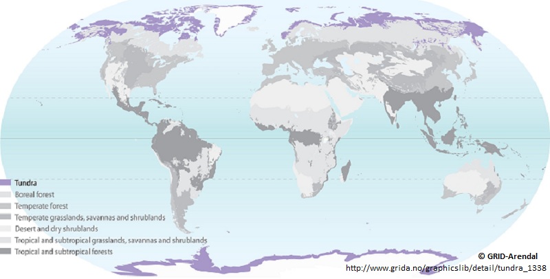

Geographer Tundra Northern Canada Map Of The Tundra . World Map Of Tundra Tundra . Tundra Biome Map Poles Location Alpine Arctic Antarctic Tundra Regions Tundra Biome Map Poles Location Alpine Arctic Antarctic Tundra Regions Ice Caps Of The . Science For Kids Tundra Biome World Map Tundra . Arctic Tundra Now A Carbon Source 2024 Report Shows Stark Changes In File 20241206 15 Rgk178





Exploring The Arctic Tundra Home 2568922 . New 2026 Toyota Tundra 1794 Edition For Sale Glen Mills PA Media Image . New 2026 Toyota Tundra I FORCE MAX TRD Pro TRD PRO 5 5 In Houston Image . 2026 Toyota Tundra TRD Pro Review Expert Insights Pricing And Trims . 2026 Toyota Tundra Dimensions 2026 Toyota Tundra 2 1280





New 2026 Toyota Tundra 1794 4D CrewMax In 350755 Gettel Automotive Cc 01 640 1G3 . First Ever 2026 Toyota Tundra HD Looks Ready For Super Duty In Fantasy . 2026 Toyota Tundra Receives Refreshing Upgrades Expedition Portal MY26 Tundra CAPSTONE 001 1536x1024 . 2026 Toyota Tundra Can It Finally Dethrone The F 150 Silverado RAM 2026 Toyota Tundra Concept 1 . New 2026 Toyota Tundra Hybrid TRD Pro 4D CrewMax In Bozeman T260418


2026 Toyota Tundra MPG Gas Mileage Data Edmunds 2026 Toyota Tundra Extended Cab Pickup Sr5 Fq Oem 1 600 . 2026 Toyota Tundra TRD Pro Revealed This 50K Beast Is The Most H60QabyQN5Q HD . 2026 Toyota Tundra Prices Reviews And Pictures Edmunds Teaser 2026 Toyota Tundra 1280 . New 2026 Toyota Tundra SR5 Trucks In Houston TX050906 Group 1 Automotive . New 2026 Toyota Tundra 4WD Platinum Hybrid 4D CrewMax TX38D656 Ken 640 01



Toyota Tundra Hybrid 2026 Review Platinum GVM Test Can The 2026 Toyota Tundra MO 1001x565 . New 2026 Toyota Tundra SR5 CrewMax 5 5 Bed In Houston TX338878 Group Cc 01 640 1J9 . New 2026 Toyota Tundra 1794 4D CrewMax TX33C554 Peterson Auto Group . New 2026 Toyota Tundra SR SR CREWMAX 5 5 In Houston TX341551 Group 1 . New 2026 Toyota Tundra 1794 Edition Hybrid CrewMax 5 5 Bed In Lubbock


New 2026 Toyota Tundra Hybrid TRD Pro Hybrid Crew Cab In . New 2026 Toyota Tundra Limited 4D CrewMax In Davis E60896 Hanlees . New 2026 Toyota Tundra 4WD SR5 Crew Cab Pickup In 344097 Gettel Cc 01 640 040 . New 2026 Toyota Tundra SR5 4D CrewMax In Ann Arbor 8864841 Victory Cc 01 640 218 . New 2026 Toyota Tundra Short Bed In Phoenix TX34A458 Penske Automall 640 01


First Ever 2026 Toyota Tundra HD Looks Ready For Super Duty In Fantasy First Ever 2026 Toyota Tundra Hd Looks Ready For Super Duty In Fantasy Land 11 . New 2026 Toyota Tundra 4WD SR Crew Cab Pickup In 352876 Gettel Cc 01 640 1G3 . Toyota Tundra Gets More Colorful And Lavish For 2026 Carscoops 2026 Toyota Tundra . Five Things To Know About The 2026 Toyota Tundra The Car Guide 675990 Toyota Tundra 2026 Cinq Choses A Savoir . 2026 Toyota Tundra HD To Debut In 2025 With Over 1 000 LB FT Leaked 2026 Toyota Tundra HD Concept 1024x597